I passed through Utah’s Grand Staircase-Escalante National Monument four years ago after visiting some of the classic highlights of the US South West, like the Grand Canyon and Zion National Park. Escalante has far fewer visitors but it’s no less impressive. This rugged landscape, filled with endless twisting canyons, was one of the last areas in the United States to be mapped and explored. I’ve been excited to get a closer look ever since.

Coyote Gulch is the most popular backpacking trip in Escalante. Imagine a wide-open canyon with massive towering walls, a gentle stream meandering through, lazy cottonwood trees to provide shade on a hot day, and the sound of birdsong echoing off the canyon walls. This secret world is all but hidden from the sandblasted desert above.

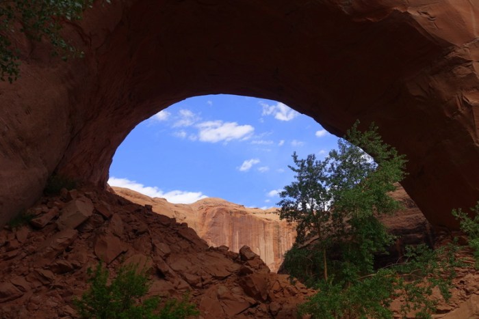
There are many ways to enter Coyote Gulch. We chose the most direct. After a short walk across slickrock and deep sand, a chasm in the earth suddenly appears. Almost straight down – hundreds of feet. It looked most intimidating.

We took our time and slowly scrambled down, using our hands nearly the entire way. For an experienced climber, it’s not that hard but we met some hikers who told us they wouldn’t even do it with a rope. Let’s just say falling here would be a bad idea.

Entering the gulch this way is very dramatic. Suddenly, you’re right in the deepest part with massive sandstone walls towering high above. Millennia of erosion have created spectacular arches and windows and pillars that seem to defy gravity.

We picked a nice spot to camp on the flat packed sand just above the stream but once I started cooking dinner, I realized I’d forgotten my spoon. Oh no! After a bit of wandering around I spotted an ideally shaped piece of driftwood. Some quick carving made it the perfect utensil. Of course, I found my spoon the next morning. I’d forgotten the sage advice: always pack your backpack in the same way so you know where everything is.


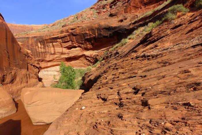
We spent two nights camping in the gulch, exploring it from the point we’d entered all the way to the confluence with the Escalante River. There are some challenging small waterfalls to scramble down or around but for the most part it’s quite a peaceful walk.


To make it all the way to the confluence with the Escalante River you have to scramble around an “impassable boulder choke”. A pile car-sized boulders are jammed into a narrowing of the canyon and the only way around is a mildly scary scramble across downward-slopping slickrock that drops off into thin air. I gingerly made my way across. On the way back up, I thought I’d have a closer look at the boulder choke from below. It looked like I could possibly squeeze through between some of the large rocks. I managed to wriggle myself through with the waterfall crashing down right beside me. Then I spotted another tight little squeeze. A few more of these awkward movements and I found myself back up at the top. So, the boulder choke isn’t so “impassable” after all. Of course, the next flood could completely change this little passage, so don’t count on in being there if you venture down the gulch.


Great shots! I think i’ll add this to my places to visit!
Thanks Laurence! If you have a chance to visit, I’m sure you’ll enjoy it. Definitely spectacular scenery.
What a place! Spectacular photos Justin, sounds like quite an adventure.
Thanks Miriam! It never ceases to amaze me how beautiful such different parts of the world can be. When I think back to my time in Australia, the landscape really couldn’t be more different, yet they’re both such awe-inspiring places.
Absolutely! You’re really getting around, aren’t you Justin. So great. Enjoy it all, the world’s a big and beautiful place.
Fantastic account of your exploration. I’ve been there for day hikes and an out and back bike ride on the water pocket fold road. I would like to bicycle the entire length if someone would drive my rig, pickup and camping trailer.