Part 1: Edziza Spectrum Range Traverse
Part 2: Crossing the Edziza Plateau (this post)
Three years after our first trip to Edziza, Jim, Calder, and I are back. This time we’ve got a bigger group. Marilyn (Jim’s partner) as well as Meg and Manrico (Marilyn’s friends) join us for what promises to be another exciting adventure.
ES: Edziza – Los Volcanes de Canadá
Tres años después de mi primer viaje a Edziza, he regresado, esta vez en un grupo de seis. Jim y Calder, mis compañeros del viaje original, volvieron también. Tres nuevos amigos nos acompañaron: Marilyn, la pareja de Jim, además de Meg y Manrico, que son amigos de Marilyn.


– Edziza está ubicado en el norte de Columbia Británica, a unos 1700 km de Vancouver. Es como ir de Lima a Quito, de Madrid a Múnich, de Medellín a la frontera con Perú o de Buenos Aires a Perito Moreno.
Alpine Lakes Air, the local float plane operator, has moved a bit north to Kluachon Lake. It’s a beautiful location, although the lake is really high and we find ourselves wading through cold water before we even get on the plane.
La aerolínea ha cambiado de ubicación. Ahora su base de operaciones está en el Lago de Kluachon, un lugar bonito y muy tranquilo.

– El camino para llegar a la avioneta está bajo el agua, debido a la gran cantidad de lluvia en la montaña
Same things haven’t changed. Calder, for example, still has his own, unique system of organization. Good thing we’ve got an extra day to get everything ready before we fly into the park.
Algunas cosas no han cambiado. Calder, por ejemplo, todavía tiene su propio sistema de organización. Es único. Menos mal que tuvimos un día adicional después de su llegada desde Nueva Escocia para prepararnos antes de tomar el vuelo rumbo al parque de los volcanes.

– Calder muestra su sistema de organización tan único
Day 1 – Buckley Lake
Alpine Lakes Air only has one plane based at Kluachon, a Cessna 206. There’s room for the pilot plus three passengers. With our group of six, that means two flights. Jim, Calder, and I are voted to take the first flight, in honour of our reunion.
Día 1 – Lago de Buckley
Alpine Lakes Air tiene solo un hidroavión con base en el Lago de Kluachon. Hay espacio para tres pasajeros. Por esta razón necesitamos tomar dos vuelos. Calder, Jim y yo tomamos el primer vuelo, como un homenaje a nuestro viaje de 2018.

– Mike, el piloto, seca el rocío de la ventanilla antes de nuestro primer vuelo
There’s nothing better than starting a backpacking or climbing trip with a ride in a helicopter or a float plane. You get a bird’s eye view of what you’re about to explore on foot.
No hay nada que me guste más que empezar un gran viaje con un vuelo en helicóptero o avioneta. Las vistas de los lagos me iban impresionando a medida que volábamos sobre el parque. Después de media hora llegamos al Lago de Buckley.

– La avioneta aterriza en el Lago de Buckley, nuestro punto de partida para un gran recorrido de la zona norte del parque
We touch down on Buckley Lake, the most accessible spot to start hiking south. From this point, you’re on your own. The next place where a floatplane can land is Mowdade Lake, our intended destination.
As we wait for our friends to arrive on the second flight, Caldar finds an old boat, but no paddles. Sometimes you have to be inventive. Luckily, he also comes across a broken rake and an old broom.
Buckley es conocido por su buena pesca. Calder encontró un pequeño bote en la zona de acampar, pero ningún remo. A veces hay que ser creativo. Remos no había, pero un rastrillo medio roto y una escoba vieja sí.

– Vamos a pescar con una escoba vieja y un rastrillo roto
We manage to catch four big tasty fish!
¡Logramos pescar cuatro peces grandes! ¡Qué éxito!

– No hay nada más delicioso que pescado fresco que acabas de pescar
Day 2 – Buckley Lake to Willie Williams Camp
The next day we start the real journey – on foot. Three years earlier Jim, Calder, and I had planned to traverse the whole park – from Little Ball Lake to Buckley. We managed to hike cross the more difficult southern section of the park but when we got halfway a large forest fire resulted in the northern half being closed. Now we’re back to explore what we missed in that first trip.
After half an hour we come upon our first obstacle, the outlet stream of Buckley. Calder impresses me with his newfound balance and flexibility, crossing the stream on a slippery log. It seems like he’s gotten younger!
Día 2 – Lago de Buckley al Campamento de Willie Williams
Al día siguiente empezamos el recorrido real. Hace tres años Jim, Calder y yo teníamos la intención de atravesar todo el parque. Logramos cruzar la parte más difícil, pero no pudimos acceder a la parte norteña por culpa de un gran incendio. Ahora exploraríamos todo lo que no pudimos ver en ese primer viaje.
Después de media hora llegamos al primer obstáculo, el arroyo que sale del Lago de Buckley. Calder me impresionó con su flexibilidad y equilibrio, cruzando el arroyo sobre un tronco resbaladizo. ¡En los tres años desde nuestro último viaje se había vuelto más joven!

– Calder nos sorprende con su gimnasia
The trail continues through the forest, passing through wet, swampy areas. There are lots of mosquitos. I keep my head-net on. When we arrive at our first camp, the mosquitos disappear. That can only mean one thing: a storm is coming.
El camino sigue por el bosque, pasando por muchos pantanos. Por consecuencia hubo muchos mosquitos durante todo el día. Al llegar al primer campamento los mosquitos desaparecieron. Eso podía significar solo una cosa: una tormenta.

– Nuestro segundo campamento con una tormenta cada vez más cerca
Day 3 – Willie Williams Camp to The Oasis
The storm never arrives. The mosquitos, luckily, don’t come back. After a good night’s rest, we make our way out of the forest and find ourselves walking on fine black sand. Edziza is known for being a lone volcano surrounded by swamps and rivers. It’s like an island of lava in a sea of trees and lakes. With each step, the landscape becomes more and more moon-like.
Día 3 – Campamento de Willie Williams a El Oasis
La tormenta nunca llegó. Los mosquitos, por suerte, no volvieron. Después de un buen descanso salimos del bosque a caminar sobre negra arena volcánica. Edziza es conocido por ser un volcán raro en medio de montañas y bosque que no tienen nada que ver con el volcanismo. Es como una isla de lava en un mar de árboles y lagos. Con cada paso el paisaje se volvía más lunar.

– Caminamos sobre arena negra y rocas volcánicas
There’s not much water as we make our way through piles of strangely-shaped rocks. Some look like gargoyles, watching over us as we pass by. I don’t like to carry much extra water, if I don’t need to. So, I’m pretty happy when we come upon a fresh spring flowing out of the lava field. This spot is known as The Oasis and the name is well-deserved. This bit of green, surrounded by sharp, barren volcanic rock, is the perfect place to camp.
No hay mucha agua a medida que caminas entre rocas extrañas, muchas veces en forma de gárgolas. No me gusta cargar agua en la mochila si no necesito. Por eso, y con un poco de sed, estaba contento de toparme con un manantial de agua pura y fresca que aparece desde la nada. Este lugar se llama El Oasis y el nombre es propicio. Rodeado de rocas volcánicas este rincón verde era el sitio perfecto para acampar. Esta vez, sí llegó la lluvia.

Day 4 – The Oasis to (a bit past) Eve Cone
We break camp late, waiting out a few morning rain showers. It never rains hard, so we decide to head out despite the light drizzle that continues for much of the day. Despite a bit of precipitation in the air, we really enjoy the views. Vibrant green vegetation jumps out amongst extensive fields of black lava.
Día 4 – El Oasis a Cono de Eva
Partimos tarde de El Oasis. Esperamos hasta que terminara la lluvia. Nunca llegó a haber un aguacero, más bien lloviznaba durante gran parte del día. A pesar de las condiciones húmedas nos gustó mucho el paisaje. La combinación de vibrantes hierbas verdes y extensos campos de lava nos impresionó.

– Caminamos bajo la llovizna y neblina con el Cono de Sidas al fondo
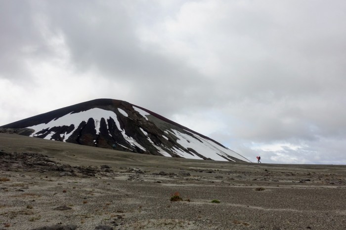
Surrounding Edziza – that is the central, heavily glaciated peak – there are more than 50 cinder cones. The most famous is Eve Cone. It has a nearly perfect conical form. Unlike all the other cones, it wasn’t blasted apart during an eruption and the wind and glaciers haven’t had time to errode it away.
Alrededor del volcán principal hay más de cincuenta conos de ceniza. El más famoso se llama Cono de Eva. Tiene una forma perfecta. A diferencia de todos los demás conos en la zona, por no hablar de gran parte del mundo, el Cono de Eva es muy joven. Tiene tan solo mil años, que no es nada en términos de geología. La erosión y los glaciares no han tenido suficiente tiempo para alterar esta forma perfecta.

– Buscamos la ruta más conveniente para subir al Cono de Eva
At the base of Eve Cone, there’s a sign asking visitors to ascend via the back of the cone, where the rock is more firm. Some people have gone up (or more likely down) the front, leaving invasive tracks in the soft sand that covers that side of the cone. What the wind and glaciers haven’t been able to do, a few footsteps have. Just a little reminder of our impact on the world.
For Jim, climbing Eve Cone is a big bucket-list item. He’s wanted to get up here for years. Finally reaching the summit is a great accomplishment!
Hay que subir por el lado de atrás. Demasiada gente ha subido o bajado por el lado en frente del sendero. Esta parte del cono está compuesta de arena y la gente ha dejado una pista invasiva de su visita. Los glaciares y el fuerte viento norteño no han cambiado este cono, pero nuestros pasos sí.
Para Jim, subir al Cono de Eva ha sido un gran reto, una meta de casi toda la vida. Así que, fue fantástico llegar a la cima.

– Celebrando en el borde de la cumbre. Parece que estamos apenas más alto que el campo al fondo, pero creeme, la subida no es tan fácil.
I decide to scramble down into the interior of the cone. It’s another world down there, as if it were a portal to the underworld. I find a few bones. What animal decided to come here and why? It doesn’t make much sense to me. There’s nothing other than sharp volcanic rock.
Bajé al interior del cono. Es otro mundo allí como si fuera la entrada al mundo subterráneo. Allí encontré algunos huesos. ¿Qué animal decidió venir aquí? No tiene ningún sentido. No hay nada más que rocas ásperas y mucho viento.

– Camino por el borde de la cima
We celebrate on the crater rim, then head back down to continue on our route. Shortly after Eve Cone, the trail disappears. From this point, you’re free to walk anywhere you like.
We walk a few hours more. The rain has cleared up and it’s even a bit sunny. We find ourselves at a large glacially-fed creek crossing. It’s churning brown and it looks angry. Contrary to what you’d expect, glacially-fed streams are at their worst on hot, sunny days. The heat and sun melt glacier ice, filling the creek with torrents of water.
Después de celebrar en la cima, bajamos del cono y seguimos por nuestra ruta. Tan solo unos cien metros después del Cono de Eva el sendero desaparece. Desde este punto estás libre para caminar donde quieras, pero hay que prestar atención.
Caminamos unas horas más. Hacía buen tiempo e incluso hacía sol. Llegamos a un arroyo glacial bastante intimidante. Al contrario de lo intuitivo, cuanto más calor haga, más difícil será cruzar los arroyos. El calor y los rayos del sol derriten los glaciares, provocando que los arroyos suban rápido.

– El arroyo más difícil de cruzar del viaje
I cross first without my pack to see how difficult it is. I make my way from one braid in the steam to another, avoiding the deepest, fastest water. It’s not a simple crossing but it’s not particularly dangerous either. The worst thing is that the water is the colour of dirty coffee, so I have to feel my way across rather than seeing where to step. Loose rocks pelt my feet. A good trick is to keep your eyes focused on the bank you’re heading for rather than looking at the violent water churning at your feet. That’s like staring at snow flakes in a blizzard.
After seeing me make my way across then back, everyone decides to make camp here and leave the stream crossing for the next day. Good decision! We manage to find some pools of water in the tundra and avoid drinking the dirty-coffee-water in the creek.
Decidí cruzar el arroyo primero sin la mochila para ver cuán difícil era. No era fácil, pero tampoco era peligroso. Lo peor es que el agua estaba muy turbia y no se veía dónde pisar. Además, la corriente era tan fuerte que rocas sueltas me golpeaban las piernas con cada paso. Después de verme luchar con la corriente, mis compañeros decidieron acampar en vez de seguir caminando. ¡Buena decisión!
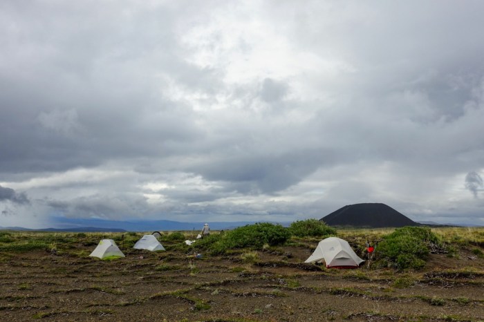
– Acampamos en la altiplanicie con el Cono de Eva al fondo
Day 5 – Eve Cone to (a bit before) Sezill Creek
The next morning the creek is much lower and we cross it without any problems. The route isn’t difficult. There’s a series of cairns that mark the route. If you look ahead toward the horizon, there’s a good chance you’ll see the next one. Some of the cairns are impressively large, so you can spot them from a long ways off. We spend the day meandering and relaxing, taking time to soak in the views of this wild landscape.
Día 5 – Cono de Eva a Arroyo de Sezill
Al día siguiente el arroyo estaba mucho más bajo y lo cruzamos sin problemas. La ruta no es difícil. Hay varios montones de rocas que marcan la ruta correcta y si miras con atención, seguro que ves el próximo en la distancia, a no ser que haya niebla o nieve. El día era relajante con muchos descansos para disfrutar de las vistas de este paisaje salvaje.

– Manrico toma un pequeño descanso
Given how murky the water was in the steam last night, we decide to camp before we get to the next glacially-fed stream, Sezill Creek. There are plenty of little streams with beautiful, clean water. Reports of long dry stretches in Edziza are greatly exagerated.
Decidimos acampar antes del Arroyo de Sezill al encontrar otro arroyo más pequeño con agua limpia. Es tentador acampar al lado de un arroyo grande, como el de Sezill, pero el problema es que el agua en estos arroyos fluye directamente desde los glaciares y está llena de muchos sedimentos. Es mucho mejor buscar agua limpia.

– Nuestro quinto campamento
Day 6 – Sezill Creek to Coffee Crater
Lots of stream crossings today! We luck out and manage to cross most of them just by rock-hopping. Calder impresses us again with this new-found agility. And, to think, he’s nearly 70 years old!
Día 6 – Arroyo de Sezill a Cráter del Café
Hay que cruzar muchos arroyos en Edziza. Teníamos suerte y logramos cruzar la mayoría sin quitarnos las botas. Calder me impresionó otra vez con su agilidad. ¡Y eso que tiene casi setenta años!

– Calder salta sobre rocas resbaladizas
The great thing about walking across a plateau like Edziza (that is, the gentle slopes below the glacier and peak itself), are the great views all along. Across the valley to the west we marvel at the Boundary Range. On the other side of these mountains lies the Pacific Ocean and Juneau, the capital of Alaska.
Hay vistas fantásticas desde la meseta alrededor de Edziza. Al otro lado de esas montañas brillantes está el mar y Juneau, la capital de Alaska.

– La Cordillera de la Frontera. Al otro lado de las montañas está Alaska.
A cold wind picks up as we work our way up long stretches of deep sand. We have to cross a glacier here but we barely notice because it’s covered in so much sand and rock. I poke my poles down through the sand and they hit hard ice.
Hacía frío a medida que caminábamos sobre campos de arena profunda. Hay que atravesar el glaciar aquí, aunque uno no se da cuenta de eso porque el glaciar está cubierto con arena y rocas. En todo caso, es mejor pisar con cuidado.
– El Cráter de Cocoa, todavía con trazos de nieve

– Cruzamos arena volcánica y escombros dejados por los glaciares
We get to Coffee Crater – I love the creative naming of the cones – and find a nearly perfectly flat area protected from the wind. On the map it looks like there’s a lake here but we find nothing more than a little pond below a melting snow slope. The sand is a touch damp but we’re happy to be out of the wind. After dinner, Calder and I do a little side-trip up to the top of Coffee Crater where the wind is still strong.
Al llegar al Cráter del Café encontramos un área casi perfectamente plana protegida del viento por el cono. El mapa indica que hay un lago aquí, pero encontramos solo una pequeña charca.

– Acampamos bajo el Cráter del Café
Day 7 – Coffee Crater to (just below) Cartoona Peak
After Coffee Crater, the landscape is austere. A big field of black lava extends toward an unnamed crater. The sand is deep and loose. Fortunately, most everyone goes the same way and a good path has formed, keeping us from sinking in so much.
Día 7 – Cráter del Café a Pico de Cartoona
El paisaje después del Cráter del Café es muy austero. Un gran campo de negras rocas de lava se extendía hacia un cono desconocido y áreas de nieve. La arena era bastante profunda y húmeda. Con cada paso nos hundíamos. Afortunadamente hay un buen camino en la arena donde todo el mundo camina.

– Nos dirigimos a través de un campo de lava hacia un cono sin nombre (hasta donde yo sé)
We’re really excited to climb the final cone on our route, Keda Cone. From the summit we enjoy panormaic vistas toward the north, where we’ve come from, and toward the south, where Jim and Calder and I walked three years before.
Teníamos muchas ganas de subir al último cono en nuestro recorrido, el Cono de Keda. Desde la cumbre hay vistas panorámicas hacia el norte, de donde habíamos venido, y hacia el sur, donde caminamos tres años atrás.

– Marilyn sube al Cono de Keda a ver la inmensidad de lo que hemos caminado
After heading back down from Keda Cone, we continue toward Chakima Pass. There are two options:
1) Head down to Walkout Creek, turn left, then up to Chakima Pass. This is our intended route.
2) From Coffee Crater you can cross over a saddle on the ridge of Cartoona Peak, continue traversing below the peak, then cross over another saddle to descend down to Chakima Creek, thus bypassing Chakima Pass.
We find ourselves a bit off-route, somewhere below the two saddles of Cartoona Peak but above Walkout Creek. It’s been a good day and there’s a nice stream with great views, so we decide to camp early.
Después de subir al Cono de Keda, seguimos hacia el Paso de Chakima. Aquí, hay dos opciones. Se puede seguir bajando hasta el Arroyo de Walkout y luego hay que girar a la izquierda para atravesar el Paso de Chakima. Teníamos en mente esta opción, pero nos encontramos un poco fuera de la ruta, así que decidimos acampar temprano, en un lugar muy bonito.

– Acampamos arriba del Arroyo de Walkout con vistas a la Cordillera del Espectro, que atravesamos hace tres años
Out of curiosity, I go for a walk in the afternoon and find the Cartoona route. It looks intriguing but the other side of the ridge is blanketed in fog, so I can’t see the way down to Chakima Creek. From what I can see, it looks more alpine in nature.
La otra opción es más difícil. Se puede caminar bajo el acantilado del Pico de Cartoona hacia un collado, es decir un paso angosto entre los puntos altos de la cresta. Después de montar las carpas, subí a la cresta para ver esta ruta. La encontré sin mucho esfuerzo, pero no podía ver nada al otro lado de la cresta por haber mucha niebla. Diría que esta opción tiene un carácter más alpino.

– Hago investigaciones para encontrar una ruta sobre la cresta del Pico de Cartoona. En el otro lado hay demasiada niebla para ver si se puede descender o no.
Day 8 – Cartoona Peek to Chakima Creek
The next morning, it’s nice and sunny and we make our way down to Walkout Creek. The contrast between the volcanic brown earth and the vibrant green vegetation in the valley below is striking. In short time, we get to Chakima Pass. From here it’s all easy downhill walking (famous last words).
Día 8 – Pico de Cartoona a Arroyo de Chakima
Al día siguiente bajamos al Arroyo de Walkout. El contraste entre el marrón de la tierra volcánica y el verde vibrante de la vegetación en el valle me impresionó. En poco tiempo llegamos al Paso de Chakima. Desde ese punto siempre iríamos en bajada.

– La vista hacia el Arroyo de Walkout
We have a nice long break above a blanket of clouds filling the valley below, not wanting to leave the alpine.
Tomamos un largo descanso arriba de las nubes, no queriendo dejar la zona alpina.
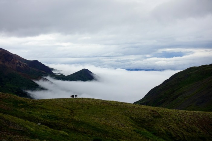
– Nubes llenan el valle del Arroyo de Chakima
At this point, we join up with our 2018 route. It takes me a few minutes to recognize where we descended from the alpine ridge high above but Jim spots it almost instantly.
En este punto del camino se cruzan nuestra ruta de 2018 y nuestro recorrido actual. Tardé unos minutos en identificar exactamente por dónde habíamos bajado, pero Jim lo reconoció al instante.

– La vista del descenso de nuestra ruta de 2018
At first, the Chakima Creek trail is well defined and it’s a pleasure to meander through fields of wildflowers.
Al principio, el camino está bien definido y es un placer deambular por las flores silvestres.

– Ha muchas flores silvestres junto al lado del Arroyo de Chakima
But after not long we find ourselves pushing through alder bushes. Sometimes they’re tall enough that it’s hard to see where to go. But it could be a lot worse.
Después de poco tiempo, sin embargo, se convierte en una selva casi impenetrable. Los arbustos eran tan altos que, a veces, ni siquiera veíamos por dónde caminar.

– Nos perdimos en los arbustos altos y espesos
We get to the Chakima horse camp but find that it’s a bit run-down. Manrico suggests that we keep walking to make our final day a little shorter, which seems like a good idea. About 650m after the horse camp we get to a nicer spot to camp. I don’t recall any other good spots further along but we decide to continue walking. Meg’s map app indicates that there’s another camp 3km further along. When we get there we find a nice spot for two tents. Hmmm. Fortunately, we’re all getting along well and manage to squeeze in all five of ours. It’s a cozy night together.
Llegamos a un campamento para caballos, pero estaba un poco descuidado. Manrico quería seguir caminando para hacer más corto el último día. Unos 650 metros después del campamento para caballos hay otro campamento de mayor calidad. Pero, a veces el deseo de continuar es fuerte. El mapa de Meg indicaba que había otro campamento a unos tres kilómetros más. Así que seguimos. Al llegar al “campamento” indicado, encontramos espacio para dos carpas. Por suerte, todos nos llevábamos bien y logramos montar todas las carpas en tal estrecho espacio.

– Este campamento apenas tiene espacio para dos carpas, ¡por no hablar de cinco!
Day 9 – Chakima Creek to Mowdade Lake
The horse trail along Chakima Creek is an adventure. Hunting parties used to come up here and clear the way for their horses but it looks like they haven’t been here for a few years. There’s just not enough wildlife left to justify commercial trips to the park.
Día 9 – Arroyo de Chakima a Lago de Mowdade
El camino junto al Arroyo de Chakima es una aventura. En el pasado, cazadores venían con sus caballos y mantenían el camino. Parece que no han estado aquí desde hace mucho tiempo.

– Los caballos y jinetes que mantienen los caminos en el parque han dejado de usar este camino. Por eso hay unos obstáculos nuevos que hacen la caminata más desafiante.
The most fun part of the trail is when the trail suddenly ends at a stream with no indication of where to go. The answer is actually pretty obvious when we remember that it’s a horse trail: just walk right down the middle of the creek. The water is pretty darn cold. To top it all off, we wade through a private-part-deep beaver pond before joining a good trail to Mowdade Lake.
La parte más divertida del camino es un tramo en el que el camino sigue un arroyo. No quiero decir que vaya al lado de un arroyo. Más bien, el arroyo es el camino. Luego, hay que cruzar un charco bastante profundo. Esto es culpa de los castores canadienses que construyen sus presas sin tener consideración por los senderistas.

– El momento más inesperado del viaje: tenemos que cruzar un charco con agua bastante fría
Finally, we make it to Mowdade, our final camp! Manrico messages the float plane company to see about getting picked up, but it’s late in the day and windy. No problem – we’re happy to spend one last night enjoying this beautiful spot.
Por fin, llegamos al Lago de Mowdade, nuestro último campamento. Manrico llamó a la aerolínea para saber si era posible tomar un vuelo esa noche, pero le respondió que ya era demasiado tarde. No importa, disfrutaríamos de nuestra última noche en todo caso.

– Estamos contentos de haber terminado el camino
Day 10 – A “Bonus” Day at Mowdade Lake
The wind picks up during the night. We wake up the next morning, take the tents down, and head over to the dock to wait for the float plane. They’ve told us it should arrive by 9:30am. At 09:29 they send us a message saying “all flights cancelled — wind too strong to fly”. I guess we’re not getting back to civilization today, after all. An hour later I hear the sound of a float plane and get excited but it turns out to be a larger plane, coming to pick up two hunters who also camped at Mowdade last night. Their larger plane can cut through the wind much better than our little guy.
Día 10 – El día inesperado en Lago de Mowdade
Durante la noche hacía mucho viento. Nos despertamos a la mañana siguiente, desmontamos las carpas y esperamos el hidroavión. “Lo escucho” grité. Pero, no, no era nuestro avión. Dos cazadores habían acampado con nosotros y su aerolínea tiene aviones más grandes y resistentes. Su piloto logró aterrizar en el lago. En cambio, nuestro piloto, con su avioneta más pequeña, nos mandó un mensaje diciendo que todos sus vuelos se cancelaron.

– Llega una avioneta, pero no es la nuestra. Tenemos que esperar un día más para que el viento se calme.
We pass the day relaxing, watching birds swimming along the lakeshore, and chatting. We eat up most of the little food we have remaining and hope that it won’t be another day (or two!) until the wind calms down. Somehow, the conversation turns to cannibalism and who looks the most tasty.
Luckily, the next morning our pilot manages to fly through the wind. I pack up in a hurry and we’re off. It’s been a great adventure and very rewarding. Edziza is a rarely visited park but it’s certainly worth the effort.
Así que, pasamos el día relajandonos, observando las aves y charlando. Comimos todo lo que nos quedaba de nuestra escasa comida. Empezamos a hablar sobre quién de nosotros se veía más delicioso. Por suerte a la mañana siguiente el viento era menos fuerte y el piloto logró venir. Así, terminamos una aventura muy divertida y gratificante. Edziza es un parque poco visitado, pero claro que vale la pena.

– Nuestra ruta a través de Edziza
Check out my trip report from our Spectrum Range trip to see how different the northern and southern parts of Edziza are.
Si quieres leer sobre nuestro viaje en el sur de Edziza, escribí el artículo antes de aprender español, así que solo está en inglés, pero puedes encontrarlo aquí: Cordillera del Espectro

Wow, I bet Sylvie was sorry she wasn’t on this one 🙂 ! What an adventure!
You’re right, Judy. She sure should be sorry she didn’t go. She was expecting the landscape to be much more barren and dry but it was quite beautiful.
6 Sept.
Hi Justin, I am sorry for the delay in responding to the wonderful trip you are having in Edziza wilderness. The photos are stunning and how wonderful to be in the pure wilderness with 5 mates enjoying yourselves. I am a little jealous about your adventures. And above it all away from all the world’s problems of the Chinese communist virus. Thanks for sharing your photos and comments. How long is your adventure or are you back again in B.C.?
All the best from Michael T.
Sounds like a great trip Justin. Did you just finish the Akshayuk Pass? I’m pretty sure I met Jim on the pass this summer at the Glacier Lake hut. I think you we scouting crossings for the Owl River. Between his description and your photos of the park, this is now on our bucket list. Thanks!
Hey Adam,
Yes, that was us in Akshayuk Pass! I’m glad Jim convinced you on Edziza. It’s beautiful and we loved our trips there, both to the volcanic cones in the north and the amazingly colourful peaks in the remote south. Jim will be super stoked to hear you have it on your bucket list.